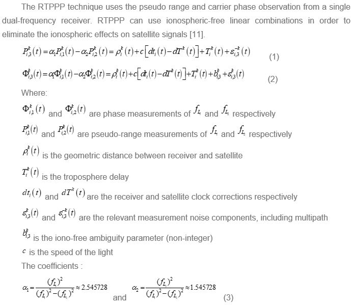
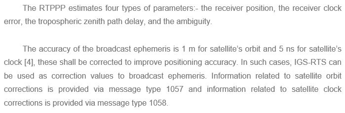
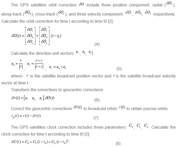
Can PHAM and Lau Ngoc NGUYEN, Vietnam
Keywords: RTPPP, IGS-RTS Corrections, Bathymetric, Maritime Applications, Real-time Kinematic Positioning, Hydrographic Surveying, Offshore Surveying
SUMMARY
At present, the real-time kinematic relative positioning techniques such as DGPS and RTK are being used widely for hydrographic surveying in order to determine the horizontal position of river/sea bottom points. Limitations of the relative positioning method require at least two GNSS receivers working at the same time and its accuracy depends on baseline length. On the other hand, the standard absolute positioning method requires one only GNSS receiver, but it provides low accuracy. Since the RTS service provides real-time corrections of the GNSS satellites orbit and clock, the RTPPP technique has appeared, which improved significantly real-time positioning accuracy. This opens up the possibility of applying RTPPP to the hydrography. We have tested the RTPPP technique at a section of Saigon River, Ho Chi Minh City, Vietnam, and compared the results with RTK technique. The results show that the accuracy of the RTPPP in East and North components are 0.26m and 0.17m respectively. This accuracy shows that the RTPPP technique meets the requirement for the hydrographic surveying at a scale of 1:1000.
- INTRODUCTION
Positioning Satellites System (GNSS) is ideally suited for onshore and offshore positioning because of its high accuracy and the short observation time. Currently, the establishment of river/sea bottom topographic maps requires the horizontal position accuracy of a few decimetres. Limitations of the relative positioning method require at least two GNSS receivers working at the same time and its accuracy depends on baseline length. On the other hand, the standard absolute positioning method requires one only GNSS receiver, but it provides low accuracy.
Since 2013, contributing to improved accuracy in real-time positioning, the International GNSS Service (IGS) has assisted users through the transmission service of the GNSS satellites orbit and clock corrections in real time. These corrections are formatted according to the RTCM-SSR standard and are transmit to the users via the Internet protocol. Since the RTS service provides real-time corrections of the GNSS satellites orbit and clock, the RTPPP technique has appeared, which improved significantly real-time positioning accuracy. This opens up the possibility of applying RTPPP to the hydrography.
Real Time Precise Point Positioning (RTPPP) is a relatively new technique of absolute positioning. Basically, RTPPP is the development of the Precise Point Positioning (PPP) technique. RTPPP uses carrier phase and pseudo range in ionospheric-free linear combination. In order to get high accuracy of survey point positions, RTPPP needs satellite orbit and clock corrections which can be got from the Real Time Service (RTS) of the IGS.
According to our previous paper [1], the accuracy of real-time kinematic positioning by using PPP with IGS-RTS corrections of the North, East and Up components is 0.19 (m), 0.25 (m) and 0.23 (m), respectively. These accuracies are improved in East (78%), North (75%) and Up (89%) components compared with single point positioning using the broadcast ephemeris (0.87, 1.01, 2.14).
This paper will present the research on the application of RTPPP for the hydrographic surveying in Vietnam, by comparing them with the RTK technique.
2. RESEARCH METHODOLOGY
2.1 Algorithm
2.2 Methedology
Some general settings for processing are given in Table 1
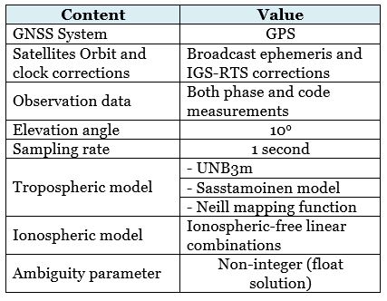
Basic flowchart for this research can be seen in Figure 1:
3. TEST STUDY
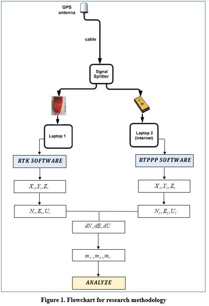
To evaluate the accuracy of RTPPP with IGS-RTS corrections, we conducted 2 types of techniques: RTK and RTPPP. The survey points by RTK techniques are used as reference points. We only use one rover antenna installed on the vessel as shown in Figure 2. The signal from the antenna will be transmitted simultaneously into 2 receiver boxes via the splitter.
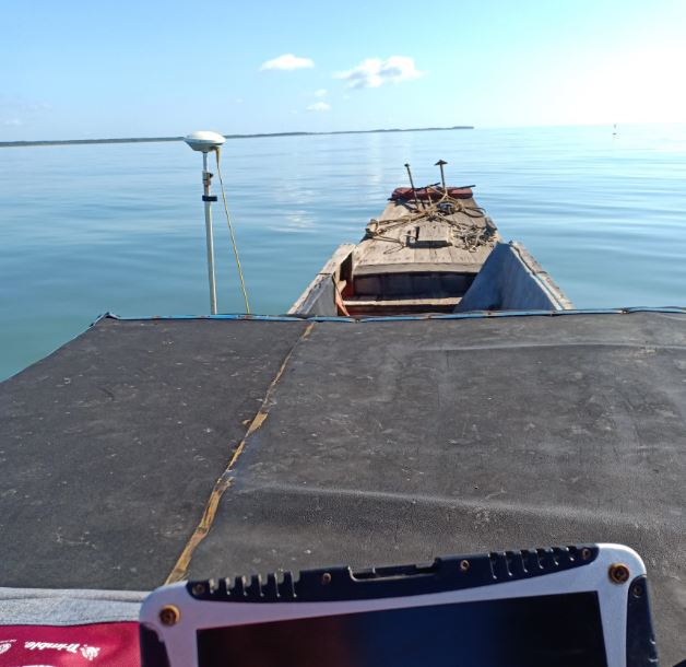
- System 1: the AT502 antenna connected to the Topcon Legacy-E receiver. It receives corrections transmitted from the base station which is setup at the benchmark BM00 in order to compute the coordinates of the AT502 antenna by the RTK technique.
- System 2: the AT502 antenna connected to the Leica SR530 receiver. It collects measurements to transmit to the laptop, while the laptop is also connected to the Internet to get RTS corrections from the IGS so that it can compute the coordinates of the AT502 antenna by the RTPPP technique.
In addition, so as to collecting depth data for the establishing hydrographic map, we installed transducer of echo sounder with AT502 antenna.
Figure 2. The base station on the point BM00 & AT502 Antenna on the vessel
The total length of the 1.5 km survey lines (Figure 3) was observed by GPS (1 hour, 28 minutes) dual frequency receivers on [2018-10-26] at Sai Gon River, Ho Chi Minh City, Vietnam. using Leica AT502 antenna with 1 second observation time interval and 10o elevation mask angle.
The reference coordinates of the benchmark BM00 was processed by Static PPP method shown at Table 2. With the accuracy of Static PPP only at the level of mm-cm [9], so it is used as the basis for comparison with RTPPP results.
Table 2. Coordinates of the benchmark BM00 in ITRF2014.
| Benchmark | Duration | X (m) | Y (m) | Z (m) |
| BM00 | 2 hours | -1803237.351 | 6000918.322 | 1186788.963 |
4. RESULTS AND DISCUSSIONS
Measurement data including coordinates and depth are collected in real time and automatically saved to the computer via Hypack software. Figure 3 shows the survey area (magenta polyline), design run lines (pink lines) and contour lines are interpolated from survey points.
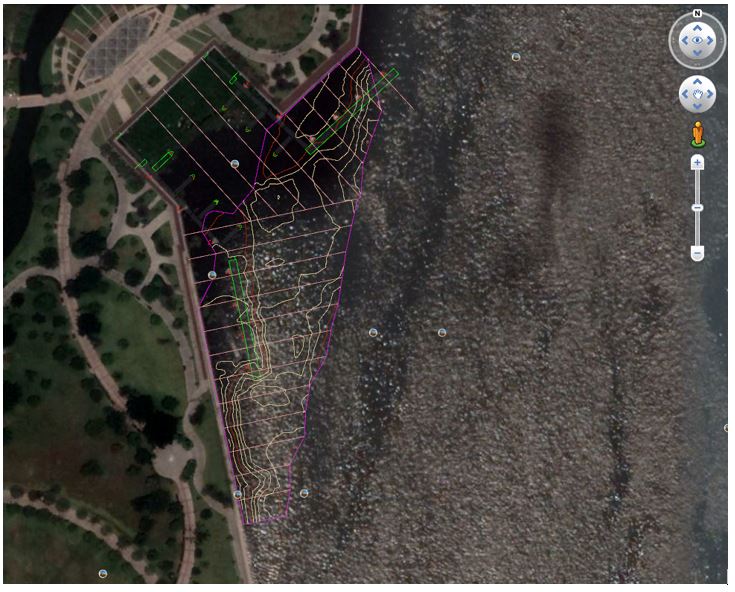
Figure 3. A layout of the project viewed on Google Earth [2018-10-26]
The horizontal coordinates values obtained from processing by RTPPP are compared with the coordinates values processed by RTK according to the following formula:
where:- (N1, E1) are the horizontal coordinates processed by RTK, and (N2, E2) are the horizontal coordinates values processed by RTPPP.
With the survey coordinates using RTK, the mode is 100% RTK fixed. Thus, the coordinate values of survey points by RTK technique are used as reference values. According to [12], the accuracy of the RTK for fix solution is only a few cm, which is sufficient to refer to when evaluating the results of RTPPP.
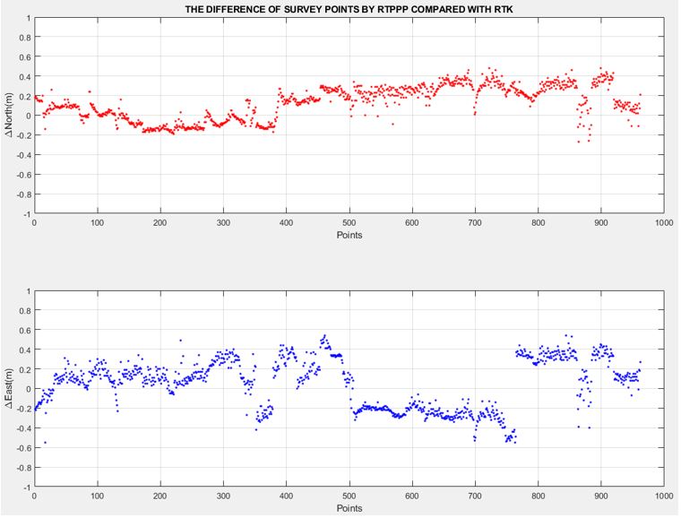
Figure 4. Analysis for the accuracy of RTPPP using IGS-RTS corrections
Table 3. Statistical results of RTPPP using IGS-RTS corrections.
| mE (m) | mN (m) | mP (m) |
| 0.26 | 0.17 | 0.31 |
Table 3 shows the accuracy of the RTPPP technique. These numbers are computed following (10) and (11). Compared with the RTK technique, RTPPP gives the horizontal accuracy about ~26 cm for Easting and ~17 cm for Northing.
Figure 4 illustrates the RTPPP results for survey points. The figure shows the RTPPP error values in the East, North directions compared with RTK technique. The X-axis refers to the number of survey points (one epoch/1 sec) and Y-axis indicates the deviation value in meter level. According to Figure 4, the deviation range of the North component from -0.2 to +0.2 m except for a few points about ~ 0.5 m deviation. Meanwhile, the range deviation of the East component from -0.3 to +0.3 m except for a few points about ~ 0.6 m deviation.
According to the document [15], the accuracy of the horizontal component of the depth points does not exceed 0.6mm on the hydrographic map, therefore, we have statistical results in Table 4.
Table 4. The accuracy of RTPPP and limit accuracy of technical requirements
| Scale | mP (m) | mPmax (m) | Comment |
| 1:500 | 0.31 | 0.30 | not yet reached |
| 1:1000 | 0.31 | 0.60 | reached |
Table 4 shows the accuracy of RTPPP technique meets the requirement for the hydrographic surveying at a scale of 1:1000. Moreover, the RTPPP approximately can meet the requirement for the hydrographic surveying at a scale of 1:500.
The IGS-RTS corrections are transmitted to users via the internet, in order to get satellite orbits and clocks corrections depend on the quality of the internet. If there is any problem with the internet connection, it will also interrupt the results of RTPPP technique.
5. CONCLUSION
The main goal of the current study was to investigate the RTPPP solutions for the hydrographic applications in Vietnam. The project has been observed on the Sai Gon River, Ho Chi Minh City, Vietnam. RTPPP software ver1.2 was used to obtain the RTPPP solution for the measurement data. The RTK solution is used as a reference solution for the RTPPP solution. The results show an RMS error of 0.26m and 0.17m for East and North respectively. This accuracy shows that the RTPPP technique meets the requirement for the hydrographic surveying at a scale of 1:1000.
RTPPP is a new promising technique in the position determining due to its efficiency and low cost. In general, RTPPP can provide results for kinematic cases with an accuracy of a few dm. With the accuracy of RTPPP, it can be applied in hydrographic surveys. Especially, we can effectively apply RTPPP technique for offshore surveying that current RTK technique cannot perform.
ACKNOWLEDGMENTS
The authors would like to thank our Company and Department of Geomatics Engineering, the Ho Chi Minh University of Technology for providing the GPS receivers. Further thanks also for Sao Viet Joint Stock Company for supporting us with the GPS signal splitter in order to conduct our study.
REFERENCES
- Nguyen Ngoc Lau, Pham Can, “Accuracy Assessment of The Precise Point Positioning Using The IGS Real-Time Corrections,” Publication in Journal of Geodesy and Cartography, Vol. 36, June 2018.
- Nguyen Ngoc Lau, Pham Can, “Improving Accuracy of Real Time Kinematic Positioning by Using PPP with IGS-RTS Corrections”, The International Conference on GeoInformatics for Spatial-Infrastructure Development in Earth & Allied Sciences (GIS-IDEAS), Can Tho University, Viet Nam, November 2018.
- Jan Kouba, Geodetic Survey Division Natural Resources Canada, “A Guide to Using International GNSS Service (IGS) Products,” Updated September 2015.
- Alfred Leick, Orono – Maine (1995), GPS Satellite Surveying.
- Yong Heo, Thomas Yan, Samsung Lim, Chris Rizos, “International Standard GNSS Real-Time Data Formats and Protocols,” International Global Navigation Satellite Systems Society, IGNSS Symposium, Holiday Inn Surfers Paradise, Qld, Australia, December 2009.
- Janet Brown Neumann, Keith J. VanDierendonck, Allan Manz, and Thomas J. Ford, “Real-Time Carrier Phase Positioning Using the RTCM Standard Message Types 20/21 and 18/19,”.
- Abdallah, A., Schwieger, V. (2015). “Kinematic Precise Point Positioning (PPP) Solution for Hydrographic Applications”. FIG Congress 2015, 17-21 May, Sofia, Bulgaria.
- CSRS-PPP (2018). Canadian Spatial Reference System (CSRS) Precise Point Positioning (PPP) service. http://www.geod.nrcan.gc.ca/products-produits/ppp_e.php. Accessed (03/10/2018).
- Nguyen Ngoc Lau, “How Accuracy GPS Precise Point Positioning Can Be Achieved,” Science & Technology Development. Vol. 12, No. August 2009.
- Nguyen Ngoc Lau, Pham Can, “Estimating the Accuracy of the IGS Real Time GPS Orbit and Clock Corrections,” The 15th Conference on Science & Technology, HCMUT, 20-Oct-2017.
- Nguyen Ngoc Lau, Ho Chi Minh City University of Technology, “Point Precise Positioning Using GPS and GLONASS Measurements,” Journal of Geodesy and Cartography, No. 15 – March 2013.
- Brian Bramanto, Irwan Gumilar and Wedyanto Kuntjoro, “RT-PPP: Concept and Performance in Indonesia Region,” November 2015.
- TCCS XX:2015/CHHVN, “Standards for Hydrographic Echo Sounding,” 2015.
- “Corps Accuracy Standards, Quality Control, and Quality Assurance Requirements,” Chapter 3, EM 1110-2-1003, 1 Jan 02.
- 63/2017/TT-BTNMT, “Technical Requirements for the Hydrographic Surveying at a Scale of 1: 5000,” December 2017.
BIOGRAPHICAL NOTES
CONTACTS
Can PHAM
Dai Nam Equipment Company Limited
No. 6/15A1, No.3 Street, Ward 15, District 11
Ho Chi Minh City
VIET NAM
Tel. +8494 540 8112
Email: phamcan0416@gmail.com
Web site: http://www.dainamhcm.net & http://sunsurveycambodia.com/